For geothermal energy

Author: admin (Page 1 of 2)

Publication in Geothermics

Check out our last paper about geological properties in a world-class carbonate #geothermal system in France: the Bathonian of the greater Paris area.

The greater Paris area has some 12 million inhabitants and 48 heating network production units that exploit the heat capacity of a 1.5 km deep aquifer, the Bathonian limestone.

This is one of the most productive aquifers in the world for district heating, with an annual output of about 1.7 TWh of energy. The current challenge for Paris is to triple the number of heating networks using geothermal energy so as to reduce dependence on fossil fuels (40% in 2020 in France).

The main aim of this study is to create a digital database and a 3D geological model of this aquifer to minimize geological risks and optimize the location of future geothermal operations around Paris.

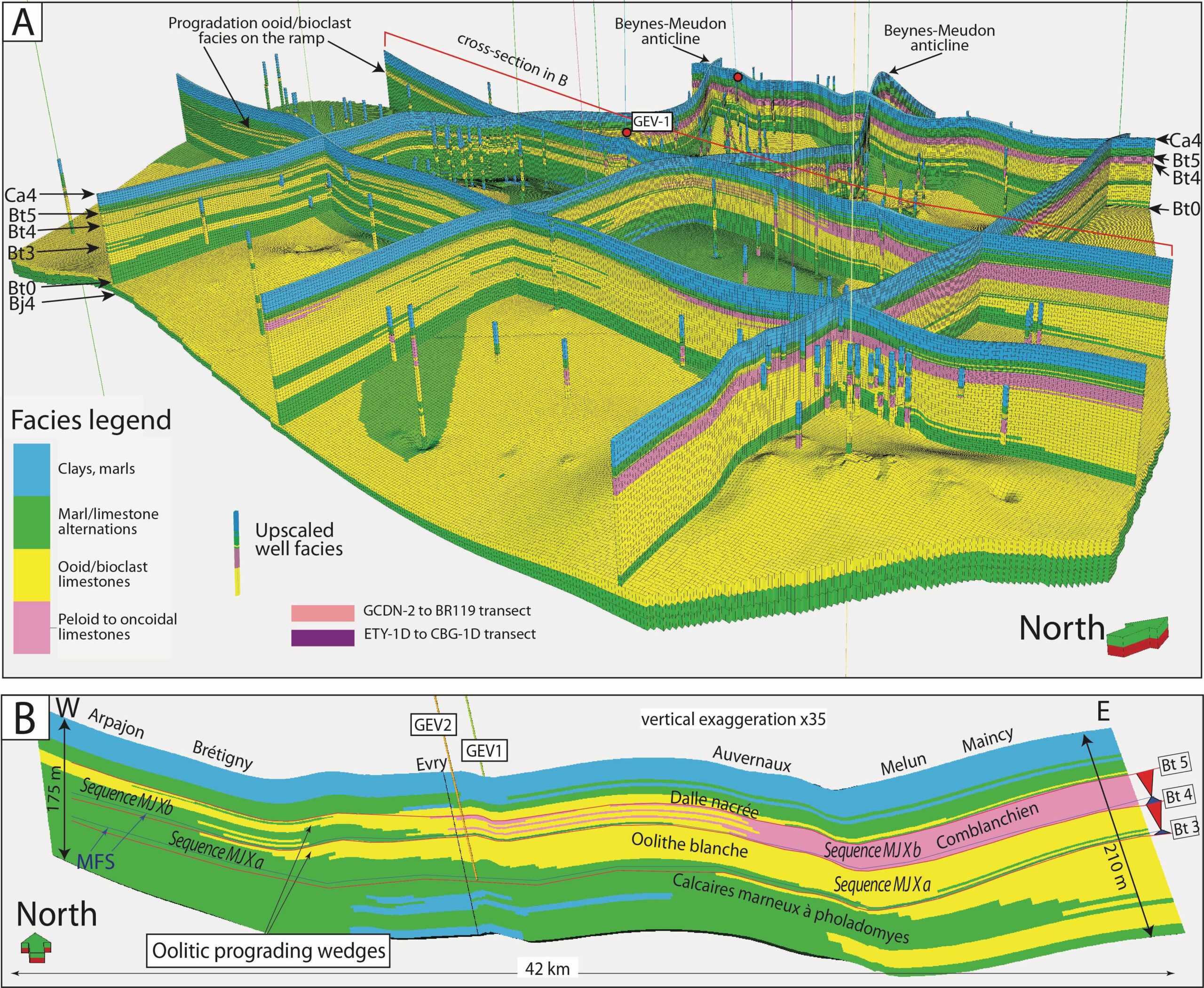
By compiling data from 168 wells, a high-resolution 3D geological model of 360 km3 size is constructed (about 40 km x 50 km x 0.2 km), made up of 12.2 million cells and displaying sedimentary facies, sequence stratigraphy, porosity (Φ) and permeability (k). About 20% of the oolitic and bioclastic facies are of good reservoir quality (Φ > 13% and k > 350 mD), especially in two targeted, high-quality reservoir sequences. These facies of interest probably correspond to giant dunes and a shoal/barrier prograding from east to west. In these facies, permeable zones are generally 4 m thick and form patches of 1600 m x 1100 m, on average, elongated perpendicular to the depositional slope.

2D and 3D maps of temperature, salinity, porosity, transmissivity, and permeability allow us to understand the areas of interest for geothermal exploration, as demonstrated around Grigny. This model helps us to apprehend better the heterogeneous character of the reservoir for geothermal prospection and to reduce the risk of future doublets during well implantation. Detailed local models may be extracted to anticipate better the implantation of new doublets in areas with already densely spaced existing wells.

Thomas, H., Brigaud, B., Blaise, T., Zordan, E., Zeyen, H., Catinat, M., Andrieu, S., Mouche, E., Fleury, M., 2023. Upscaling of geological properties in a world-class carbonate geothermal system in France: From core scale to 3D regional reservoir dimensions. Geothermics, 112, 102719 https://doi.org/10.1016/j.geothermics.2023.102719

A- 3D facies model. B- Cross-section along the carbonate platform (Thomas et al., 2023).

[In progress] 3D outcrop modeling of the deltaic Roda Sandstones using drone photogrammetry

A digital outcrop model of the deltaic system of the Roda Sandstones (“Y body”, Early Eocene, South Pyrenean Basin) has been realized using drone photogrammetry. It is then interpreted thanks to the Virtual Reality Geological Studio (VRGS) software.

It enables to trace sedimentary and stratigraphic surfaces, digitize sedimentological sections acquired during the fieldwork, paint facies, and georeference sample points etc… It is also possible to extract quantitative data: dip data, various measurements, even in inaccessible zones of the outcrop.

This step is crucial for the understanding and the reconstruction of the prograding sand bodies within the study of the heterogeneities in a fluvial-dominated and tidal-influenced delta. The digital outcrop model and the interpretation elements will then be used as a base to build a static geological model filled with facies and reservoir properties (porosity, permeability).

First results will be presented at Vienna during the EGU General Assembly 2023:

https://meetingorganizer.copernicus.org/EGU23/EGU23-565.html

Mas, P., Bourillot, R., Brigaud, B., Deschamps, R., and Saint-Bezar, B., 2023. From 3D digital outcrops to fluid flow reservoir simulations in a deltaic system: An integrated approach, EGU General Assembly 2023, Vienna, Austria, 24–28 Apr 2023, EGU23-565, https://doi.org/10.5194/egusphere-egu23-565

New publication

New publication of UPGEO team published in Energies: A Generalized Finite Volume Method for Density Driven Flows in Porous Media https://doi.org/10.3390/en14196151

UPGEO Annual meeting

Annual meeting of the UPGEO project on September 09, 2021: a multitude of highly convincing and interesting results, which stimulate very interesting discussions on sedimentology of sandstones or carbonates, neural networks, geostatistics, thermal and dynamic connectivity of reservoirs, or on flow simulation software applied to geothermal systems. The integration of various themes (Maths, Geology, Hydro-dynamics) is at the heart of our project: the goal is to successfully implement future geothermal systems. Congratulations to our PhD students Perrine Mas, Adrien Beguinet, Maxime Catinat, Hadrien Thomas, as well as Codjo Essou for the quality of their work and their investment in the project!

UPGEO at the European Geothermal PhD Days 2021

https://www.meet-h2020.com/meet-geothermal-winter-school-2021/embed/#?secret=h5m786dfYV

Maxime Catinat presentation named : « NMR contribution in sub-horizontal well for porosity-permeability heterogeneity characterization in limestones: implications for 3D reservoir prediction and flow simulation in a world class geothermal aquifer » 18th of February 2021

Hadrien Thomas and Perrine have also presented their works during a virtual poster session.

Flash talk of Maxime Catinat, describing problematic, objectives and first results of his PhD:

Flash talk of Hadrien Thomas, describing problematic, objectives and results of a part of his PhD:

Contribution of drone photogrammetry to 3D outcrop modeling of facies, porosity, and permeability heterogeneities in carbonate reservoirs (Paris Basin, Middle Jurassic)

This study showcases the value of drone photogrammetry in creating a meter-scale geological model of complex carbonate geobodies. Although drone photogrammetry is now commonly used for modeling the sedimentary facies and architecture of sandstone outcrops, its use is not widespread in creating geomodels of carbonate geobodies. Drone photogrammetry can generate accurate line-drawing correlation and detailed architecture analysis along inaccessible vertical faces of outcrops and permits observations of unreachable places. This work models the Bathonian limestones of Massangis quarry (Burgundy) as an example. The quarry covers an area of 0.4 km2 and is considered as an analogue for the Oolithe Blanche geothermal reservoir in the center of the Paris Basin. The Massangis quarry model represents a good analogue for reservoir microporosity and secondary porosity associated with dedolomitization. Ten facies are described and grouped into three facies associations (1) clinoforms, (2) tidal to subtidal facies, and (3) lagoonal facies. The clinoforms are sets of very large marine dunes 15–20 m high that prograded N70° across the platform as part of a regressive systems tract. Moldic rhombohedral pore spaces associated with dedolomitization are well-expressed within clinoforms and in the bioturbated levels of lagoonal facies. Drone photogrammetry combined with the “Truncated Gaussian with Trends” algorithm implemented in Petrel® software is used to create a geological model that faithfully reproduces the facies architecture observed in the quarry cliffs. Drone photogrammetry can be combined with field work to describe and locate facies and so constrain the spatial distribution of petrophysical properties. It also helps constraining the shapes of geobodies in the model grid for more realistic geological static models and helps providing 3D petrophysical models from an outcropping analogue for geothermal and petroleum reservoirs.

https://doi.org/10.1016/j.marpetgeo.2020.104772

Fieldwork in Charentes and Pyrénées

Within the framework of the ANR UPGEO project, that aims to characterize and understand the heterogeneity of geothermal reservoirs, a fieldwork was carried out from 29 June to 5 July in the Charentes (Aquitaine Basin, France) and in Spain (Tremp Basin, Pyrénées montains). This fieldwork, bringing together sedimentologists from GEOPS/Université Paris-Saclay (Maxime Catinat, Hadrien Thomas, Benjamin Brigaud, Bertrand Saint-Bezar), Bordeaux INP/Université de Bordeaux (Raphaël Bourillot, Hugues Féniès, Philippe Razin, Baptiste Hersant) and CVA (Eric Portier), aimed to photograph by drone the high-quality outcrops and to sample these key outcrops that may be considered as analogous to carbonate and sandstone geothermal reservoirs. For carbonates, the selected analogue was the margin of a carbonate platform evolving during the Bathonian (165 Ma), north to the Aquitaine Basin. For sandstones, the Roda sandstones (Roda de Isabena) were selected and studied for their potential analogue qualities to many estuarine sandstone reservoirs. These sands/sandstones outcrop in the southern Pyrenees, on the northern edge of the Tremp Basin, and they have been deposited in a paleo-estuary during the Ypresian (50 Ma). The objectives were to photograph the outcrops by drone to restore 3D models by photogrammetry and to record sedimentological logs, which will enable the samples collected to be placed precisely in space. After studying the samples and thin-sections in the laboratory, such as porosity/permeability, granulometry, petrographic measurements, the objective will be to integrate all these data into the Petrel geo-modeler in order to simulate flows (velocity, temperature) or cold bubble displacement in a geothermal exploitation context, taking into account heterogeneities at different scales.

« Older posts

© 2025 UPGEO

Theme by Anders NorénUp ↑