benjamin brigaud

sédimentologue

Automated petrographic image analysis by supervised and unsupervised machine learning methods

Check out our recent research on automated petrographic image analysis using supervised and unsupervised machine learning methods.

Azzam, F., Blaise, T., & Brigaud, B. (2024). Automated petrographic image analysis by supervised and unsupervised machine learning methods. Sedimentologika, 2(2). https://doi.org/10.57035/journals/sdk.2024.e22.1594

This study explores the application of machine learning techniques to automate and enhance petrographic workflows, focusing on grain segmentation and feature extraction. We present two novel software tools: GrainSight, which utilizes a supervised deep learning model (FastSAM) for automated grain detection and morphological characterization; and PetroSeg, which employs an unsupervised segmentation approach to explore rock properties and calculate porosity.

GrainSight application significantly improves efficiency and accuracy compared to manual methods. The FastSam model enables rapid and accurate grain detection and extraction of morphological features, which can provide insights into depositional environments, sediment routing systems, and reservoir quality.

PetroSeg, on the other hand, offers an exploratory approach for porosity quantification, identification of mineral associations, and characterization of textural domains.

Both methods offer unique advantages and demonstrate the potential of machine learning in petrographic analysis. Utilizing these tools has the potential to greatly enhance efficiency, objectivity, and data processing, thereby enabling new opportunities for teaching, research, and applications across multiple geological fields. The code of the two applications, GrainSight and PetroSeg, is open-source, available on GitHub and data.gouv.fr.

Grainsight : https://www.data.gouv.fr/fr/datasets/grainsight/

Petroseg : https://www.data.gouv.fr/fr/datasets/petroseg/

The U-Pb Dating Method Reveals the Secrets of Ancient Karsts in the Paris Basin!

Discover our latest scientific findings on the U-Pb method applied to the phenomenon of karstification in Geology journal and the CNRS newsletter.

Our study demonstrates that the in-situ dating method for very ancient karst speleothems can provide quite precise dates. These datings reveal that the karst in the Oligocene carbonates of the Paris Basin formed 29 million years ago—right after the rock itself! This is a major breakthrough that sheds light on the evolution of landscapes and groundwater systems.

This work is the result of close collaboration with colleagues from BRGM as part of the RGF “Paris Basin” project.
🔗 RGF Paris Basin Project

🔬 Reference:
Moreau, K., Brigaud, B., Andrieu, S., Briais, J., Quesnel, F., 2024. Determining the age and origin of a Tertiary karstic system by in situ U-Pb geochronology on speleothems. Geology 52, 689–694. https://doi.org/10.1130/G52263.1

🔗 CNRS article

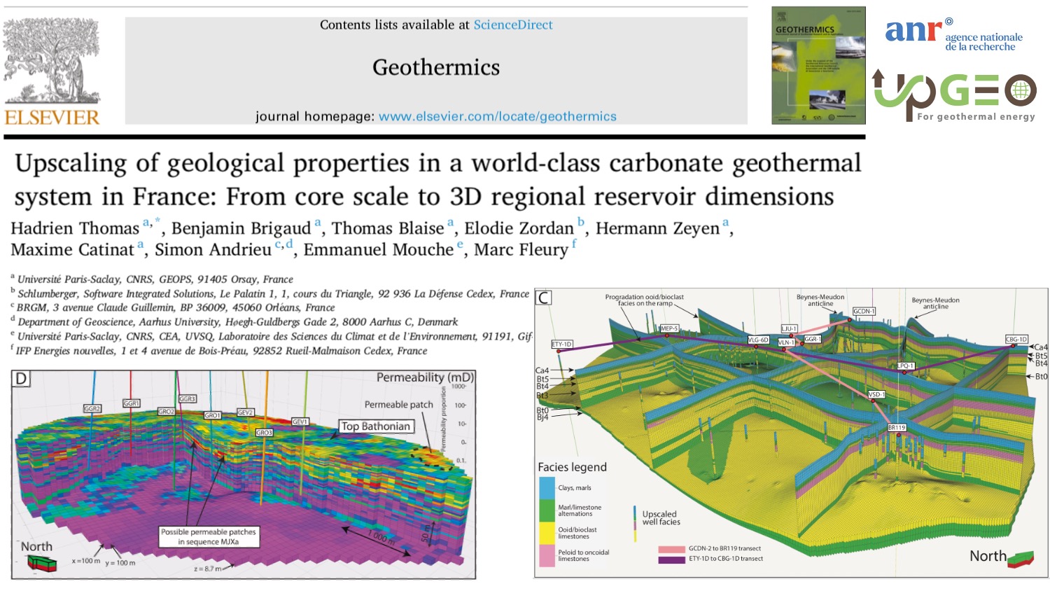
Publication in Geothermics

Check out our last paper about geological properties in a world-class carbonate #geothermal system in France: the Bathonian of the greater Paris area.

The greater Paris area has some 12 million inhabitants and 48 heating network production units that exploit the heat capacity of a 1.5 km deep aquifer, the Bathonian limestone.

This is one of the most productive aquifers in the world for district heating, with an annual output of about 1.7 TWh of energy. The current challenge for Paris is to triple the number of heating networks using geothermal energy so as to reduce dependence on fossil fuels (40% in 2020 in France).

The main aim of this study is to create a digital database and a 3D geological model of this aquifer to minimize geological risks and optimize the location of future geothermal operations around Paris.

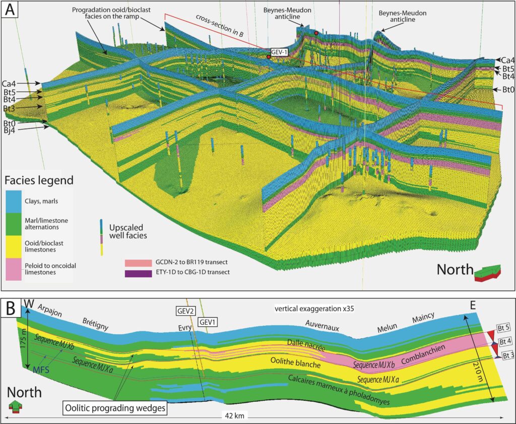
By compiling data from 168 wells, a high-resolution 3D geological model of 360 km3 size is constructed (about 40 km x 50 km x 0.2 km), made up of 12.2 million cells and displaying sedimentary facies, sequence stratigraphy, porosity (Φ) and permeability (k). About 20% of the oolitic and bioclastic facies are of good reservoir quality (Φ > 13% and k > 350 mD), especially in two targeted, high-quality reservoir sequences. These facies of interest probably correspond to giant dunes and a shoal/barrier prograding from east to west. In these facies, permeable zones are generally 4 m thick and form patches of 1600 m x 1100 m, on average, elongated perpendicular to the depositional slope.

2D and 3D maps of temperature, salinity, porosity, transmissivity, and permeability allow us to understand the areas of interest for geothermal exploration, as demonstrated around Grigny. This model helps us to apprehend better the heterogeneous character of the reservoir for geothermal prospection and to reduce the risk of future doublets during well implantation. Detailed local models may be extracted to anticipate better the implantation of new doublets in areas with already densely spaced existing wells.

Thomas, H., Brigaud, B., Blaise, T., Zordan, E., Zeyen, H., Catinat, M., Andrieu, S., Mouche, E., Fleury, M., 2023. Upscaling of geological properties in a world-class carbonate geothermal system in France: From core scale to 3D regional reservoir dimensions. Geothermics, 112, 102719 https://doi.org/10.1016/j.geothermics.2023.102719

A- 3D facies model. B- Cross-section along the carbonate platform (Thomas et al., 2023).

Calcite uranium–lead geochronology applied to hardground lithification and sequence boundary dating

Hardground discontinuities within carbonate platforms form important stratigraphic surfaces which can be used at basin scale to correlate sequence boundaries. Although these surfaces are commonly used in sequence strati‐graphy, the timing and duration of hardground lithification and the crystallization of early cements remain unexplored. Here, early calcite cements were dated by U‐Pb geochronology for five Jurassic hardgrounds, interpreted as third‐order sequence boundaries, situated within a well‐constrained petrographic, sedimentological and stratigraphic framework. The consistency or the slight deviation between the age of the cements and the stratigraphic age of deposition of the formations illustrate that cementation occurred early in the diagenetic history. The ages obtained on dogtooth cements, replacing aragonite in gastropod shells and pendant cements in intergranular spaces, match those of the standard Jurassic biostratigraphic ammonite Zones, making calcite U‐Pb geochronology a promising method for dating third‐order sequence boundaries of depositional sequences and refining the Jurassic time scale in the future.

https://doi.org/10.1111/sed.12795

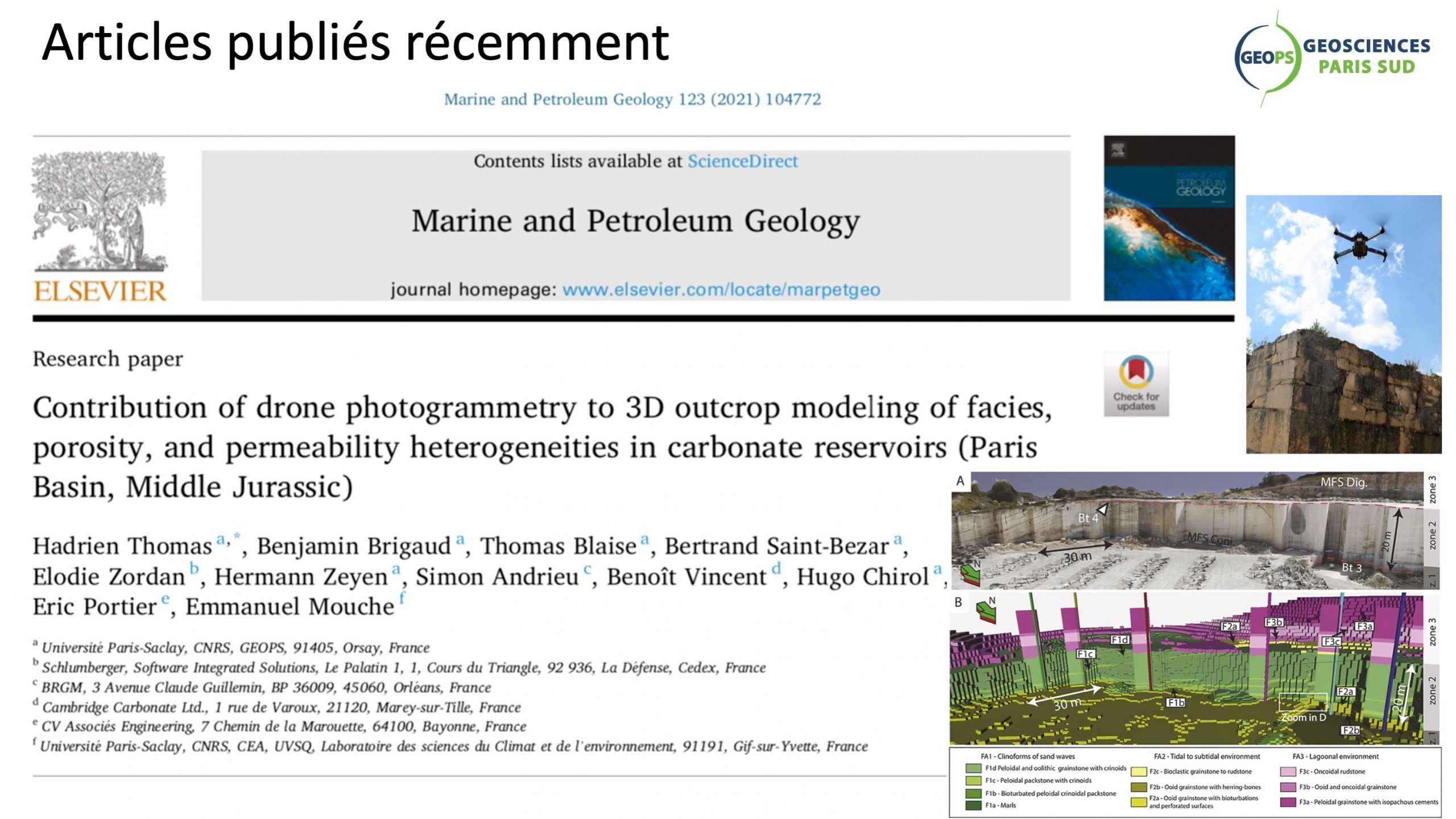
Contribution of drone photogrammetry to 3D outcrop modeling of facies, porosity, and permeability heterogeneities in carbonate reservoirs (Paris Basin, Middle Jurassic)

This study showcases the value of drone photogrammetry in creating a meter-scale geological model of complex carbonate geobodies. Although drone photogrammetry is now commonly used for modeling the sedimentary facies and architecture of sandstone outcrops, its use is not widespread in creating geomodels of carbonate geobodies. Drone photogrammetry can generate accurate line-drawing correlation and detailed architecture analysis along inaccessible vertical faces of outcrops and permits observations of unreachable places. This work models the Bathonian limestones of Massangis quarry (Burgundy) as an example. The quarry covers an area of 0.4 km2 and is considered as an analogue for the Oolithe Blanche geothermal reservoir in the center of the Paris Basin. The Massangis quarry model represents a good analogue for reservoir microporosity and secondary porosity associated with dedolomitization. Ten facies are described and grouped into three facies associations (1) clinoforms, (2) tidal to subtidal facies, and (3) lagoonal facies. The clinoforms are sets of very large marine dunes 15–20 m high that prograded N70° across the platform as part of a regressive systems tract. Moldic rhombohedral pore spaces associated with dedolomitization are well-expressed within clinoforms and in the bioturbated levels of lagoonal facies. Drone photogrammetry combined with the “Truncated Gaussian with Trends” algorithm implemented in Petrel® software is used to create a geological model that faithfully reproduces the facies architecture observed in the quarry cliffs. Drone photogrammetry can be combined with field work to describe and locate facies and so constrain the spatial distribution of petrophysical properties. It also helps constraining the shapes of geobodies in the model grid for more realistic geological static models and helps providing 3D petrophysical models from an outcropping analogue for geothermal and petroleum reservoirs.

https://doi.org/10.1016/j.marpetgeo.2020.104772

Contribution of drone photogrammetry to 3D outcrop modeling of facies, porosity, and permeability heterogeneities in carbonate reservoirs (Paris Basin, Middle Jurassic)https://t.co/Jmrb1mbuML pic.twitter.com/cA6PGdhcVg— Benjamin Brigaud (@benj_brigaud) November 28, 2020

© 2025 benjamin brigaud

Theme by Anders NorénUp ↑